Rain showers continue across several states in the country. According to the Indian Meteorological Department (IMD), conditions are becoming favorable for the withdrawal of the southwest monsoon. On September 23, IMD issued an alert for moderate to heavy rainfall in Nagaland, Mizoram, Manipur, Tripura, Assam, Meghalaya, Odisha, Andhra Pradesh, Chhattisgarh, Karnataka, Maharashtra, Kerala, and Telangana.
Delhi Weather Update
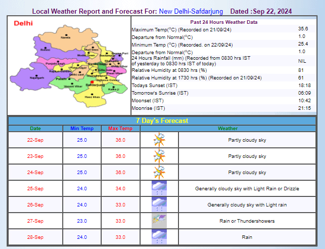
The weather in Delhi has remained clear over the past 2-3 days. The rise in temperature due to bright sunshine during the day has been noticeable. IMD predicts another spell of rain in Delhi starting from September 25, which could continue until September 28. According to IMD, Delhi's maximum temperature this week is likely to range between 33 to 36 degrees Celsius, while the minimum temperature may hover around 23 to 25 degrees Celsius.
Weekly Weather Outlook
National Weather Overview
According to the weather forecasting agency Skymet, light to moderate rain is expected in the Andaman and Nicobar Islands, Odisha, and West Bengal this week. Scattered to moderate showers are forecast for Bihar, Jharkhand, West Bengal, and Sikkim over the next five days. Light rain may continue for the next two days.
Between September 23 and 24, Odisha may experience rain, and Nagaland, Manipur, Mizoram, and Tripura could see rain from September 23 to 26. Arunachal Pradesh, Assam, and Meghalaya are anticipated to have hot and humid weather during the same period. Heavy rainfall is likely in Chhattisgarh from September 23 to 26, in Vidarbha and eastern Madhya Pradesh from September 24 to 26, and in western Madhya Pradesh on September 25 and 26.

Source: aajtak
National Weather Activities
As per Skymet, conditions are becoming favorable for the withdrawal of the southwest monsoon from western Rajasthan and Gujarat's Kutch region in the next 2 to 3 days. The monsoon trough at sea level will extend from Bikaner, Sagar, Jamshedpur, and Digha, curving towards southeast until the east-central Bay of Bengal. A cyclonic circulation area persists over northeastern Rajasthan.
Furthermore, another cyclonic circulation exists over the west-central and adjoining southwest Bay of Bengal from 3.1 to 5.8 km above sea level. An upper cyclonic circulation area is expected to develop over the northern Andaman Sea within the next 24 hours, likely moving northwest. This might lead to the formation of a low-pressure area around September 23 over the northwest and adjoining west-central Bay of Bengal.


