Imagine how the world map would appear if countries like Canada and Mexico became part of America, Russia reverted to the USSR, and Afghanistan and Pakistan merged into a unified India. Yet, this is not anticipated to occur anytime soon. Currently, a map is trending on social media, known as the New World Order Map, originating 82 years ago before World War II. Before discussing its details, one wonders why it has suddenly gained popularity online.
Donald Trump is gearing up to take control of America, and famously has expansionist desires. He is keen to make Canada the 51st state of the US and also wishes to seize Greenland. Such aspirations raise the question: will Trump stop once achieving these goals? If Canada and Greenland become part of America, wouldn't Mexico be next on his agenda? Amidst speculation, the New World Order Map has started to gain traction online. Let's delve into what exactly the New World Order Map encompasses and which countries it mentions.
What is the New World Order Map?
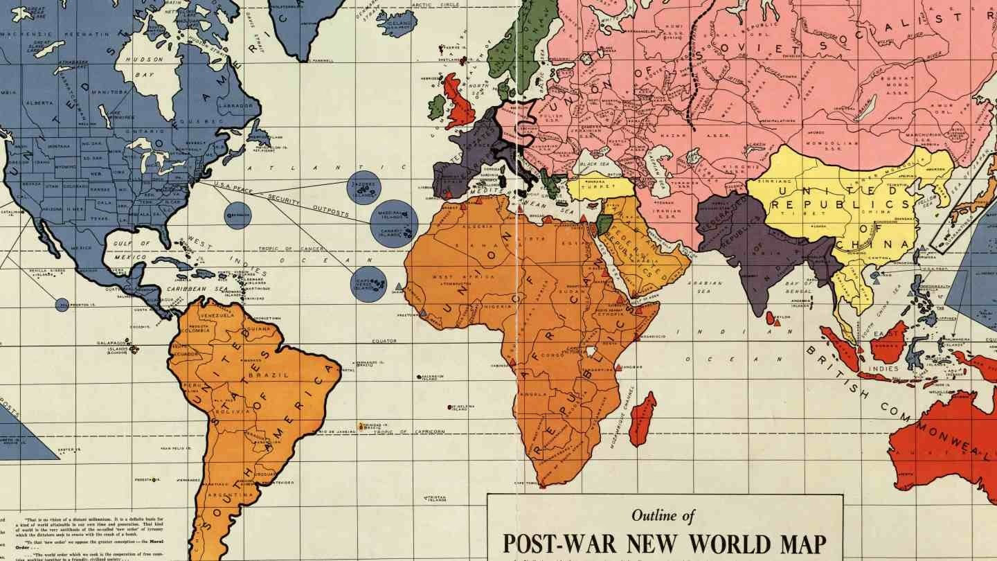
According to a report by Big Think, the New World Order Map was first published in 1942. Maurice Gomberg, in Philadelphia, Pennsylvania, USA, created it. Maurice claimed that after World War II, significant changes would manifest in the world's geography, reducing global countries to just 15. Let's explore what was said about each nation in the map.
America's Prospects According to the Map
Maurice Gomberg, originally from Russia, settled in America. His interpretation suggested the US would emerge as a great military power, incorporating Canada and all Central American countries like Guatemala, Panama, Nicaragua, El Salvador, Costa Rica, Honduras, Belize, the Dominican Republic, and Cuba. Additionally, Caribbean countries such as Antigua, the Bahamas, Barbados, and Dominica would be part of America, along with Greenland, Iceland, and Mexico.
Russia's Portrayal in the Map
Back in 1942, when Maurice released this hypothetical map, Russia was then the USSR. Maurice depicted Russia as strong, similar to the United States. The USSR's map included today's Iran, Mongolia, Manchuria, Finland, and parts of Eastern Europe, along with substantial sections of Austria and Germany.

Source: aajtak
Introduction of a New Country: USSA
The map comprises a new country named United States of South America (USSA), which includes all South American nations, along with Guyana, Suriname, French Guiana, and the Falkland Islands.
Mention of Arabian Countries' Union
The map also talks about the Union of African Republic (UAR), referring to a consortium of African republics. Additionally, a new Arabian Federated Republic (AFR) is proposed, comprising Middle Eastern countries like Saudi Arabia, Iraq, and Syria.
Composition of Unified India in the Map
Maurice designed a map of India aligning with a powerful united India, including today's Afghanistan, Pakistan, Nepal, Bhutan, Bangladesh, and Myanmar. It's noteworthy that this map was created before India's independence from British rule in 1942, and was labeled Federation Republic of India.
Integration of Korea, Thailand, and Laos into China
Instead of China, this map presents a United Chinese Republic (URC), incorporating both Koreas, Vietnam, Laos, Cambodia, Thailand, and substantial areas of Malaya within China.
Amalgamation of Germany, France, and Spain
Major European countries like Germany, France, Switzerland, Spain, Portugal, and Italy are depicted as part of a United States of Europe (USE).


