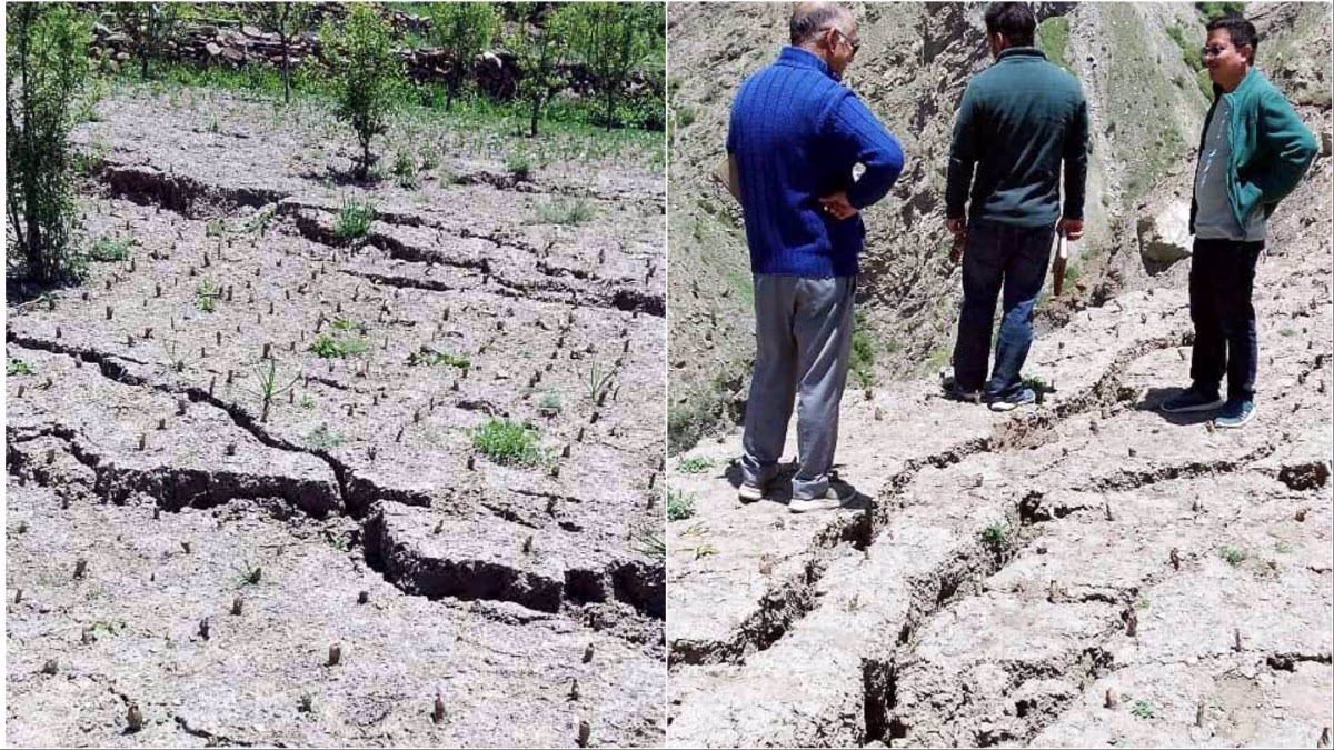
Amidst the breathtaking heights of Himachal Pradesh's Lahaul-Spiti district, the people of Lindur Village grapple with a growing concern. The ground beneath their feet teeters on instability, as cracks keep emerging much like the worrisome precedents set last year. Four houses were immediately declared unsafe back then, instilling a sense of urgency that remains unfaded.
Perched at 10,800 feet, Lindur has drawn scrutiny from the Geological Survey of India (GSI) and IIT Mandi. Previous reports highlighted the critical need for relocation, triggered by water seepage in five reservoirs directly above the village, undermining its very foundation.
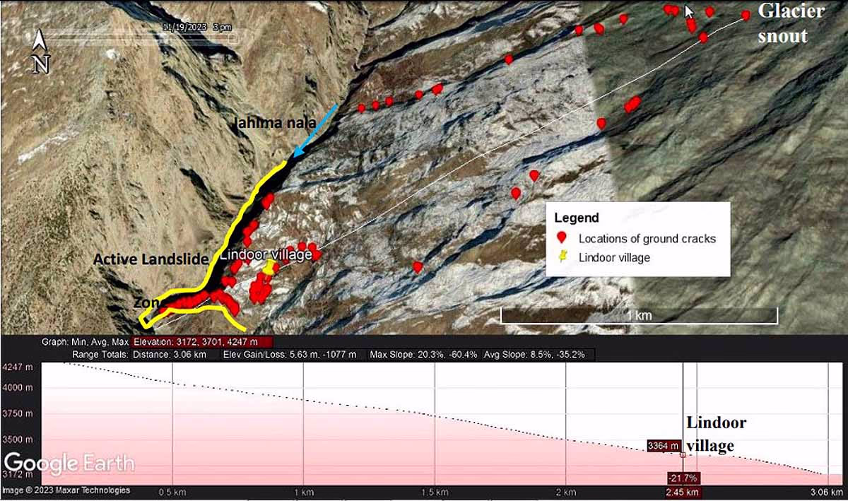
In the village's vicinity, the Jahalma stream's incessant erosion spells further trouble. The narrative of these unsettling disruptions actually began around two decades ago. The tale, once narrated by village representative Hiralal, seemingly evanesced until last year.
Discover Lindur Village and Its Perilous Location
Source: aajtak
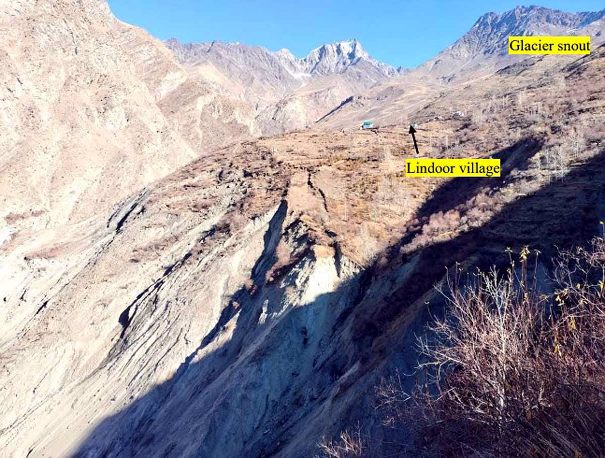
Lindur sits just 31 kilometers from Keylong town, close to State Highway 26. The village exists in precarious harmony at 10,800 feet above sea level on the bank of Jahalma stream, an offshoot of the Chandrabhaga River. The last study by GSI revealed most fissures proximal to the stream, amid persistent signs of landslides and shifting soil, stretching up to elevations of 11,030 feet.
The village's precarious state speaks of an ancient mound of soil and debris. It lies enveloped by the Great Himalayan Range, with peaks spiraling from 10,826 to 14,763 feet. Northeastwards, the face of a glacier looms, with its meltwaters trickling down through various streams, merging with the lifeblood of the village.
Source: aajtak
Villagers cherish this glacier as their sole water source, replete with rocks belonging to the metamorphic group – a tapestry woven of quartzite and phyllite. On gentler slopes, the land acquiesces to agriculture, sustaining the pride of those who toil. Last year's survey painted a chilling possibility of a catastrophic landslide waiting to strike.
Just 250 to 300 meters from the village, two unpredictably volatile landslide-prone areas were identified. The living memory of cracked homes underscores the terror of the village's reality: the earth beneath could shift at any time.
Consisting of 14 homes, a monastery, a primary school, and community centers, these structures – primarily of local stone and earth – may hold mysteries over a century old. The very existence of these buildings is now tentative, with fears of collapse ever-present. When fissures last appeared, warnings were issued as cracks spanned from mere centimeters to a formidable 1.5 meters, disrupting even the roots of trees.
Earth Trembles and Fate Hangs in the Balance
From 1900 to November 2023, Lindur has been the locus of numerous mild earthquakes. The village stands on delicate soil, where extensive seepage could manifest as a hidden pathway for water or a harbinger of landslides. GSI's studies indicate the village's temporary slope positioning as one susceptible to being swallowed entirely by a single disaster – be it an excessive glacier melt, cloud burst, or severe tremor. The future looms uncertain, as large-scale landslides threaten to dispatch the village into Jahalma stream and the potential for further fissures looms ever close.
Water seepage continues to weaken the area, demanding constant vigilance. Effective irrigation and relocation plans must be considered as looming concerns grow with the coming of each rainfall. The enduring risk of the village's descent remains a dark cloud over Lindur.