
The world was captivated by the Iranian Shahed drone that ventured dangerously close to the USS Abraham Lincoln aircraft carrier in the Arabian Sea. The U.S. military saw it as a threat and took it down, but many wonder how the drone got so near. Is China's satellite network playing a hidden role?
Recent reports indicate that Iran is harnessing China's advanced satellite network, which surveils U.S. naval ships around the clock. This sophisticated network delivers high-resolution images, video, signal intelligence (SIGINT), and electronic intelligence (ELINT).
Additional Insight: The strategies of the Baloch Liberation Army against Pakistan's forces—how many fighters do they have?
The Story Behind the Incident
While Iran's satellite capabilities are limited, China's People's Liberation Army boasts one of the most expansive and advanced satellite systems worldwide. This network aids Iran by providing accurate locations, electronic signals, and images of U.S. ships.
This real-time targeting facilitates Iran in directing drones and missiles accurately. It creates a 'kill chain' in regions like the Persian Gulf, Gulf of Oman, and the Arabian Sea, from identifying to engaging targets.
Source: aajtak
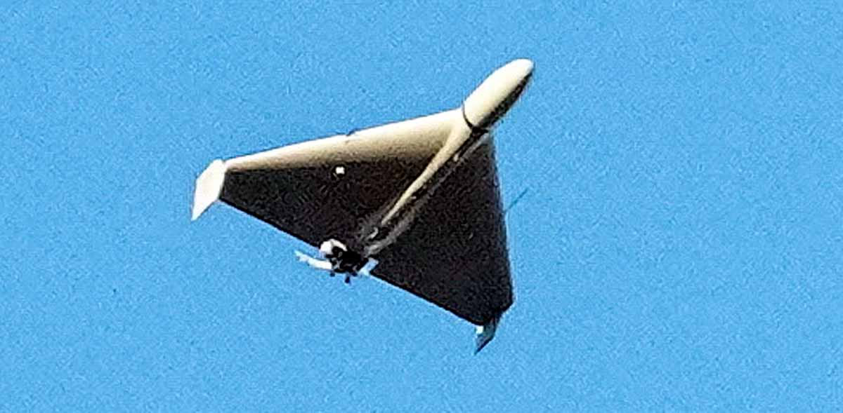
Iranian drones like these monitor ships like the USS Abraham Lincoln. Although they can be easily downed in combat, utilizing satellite or drone triangulation offers precise ship locations, with data reaching missiles in milliseconds. China's satellites are pivotal in this Iranian endeavor.
The Foundation of China's Satellite Network
Think of China's satellite system as a well-stocked toolbox, each tool with a unique function. In contrast, Iran lacks such comprehensive assets. China's satellites possess intelligence, reconnaissance, and surveillance capabilities, capturing Earth's imagery and radio signals in all weather conditions.
There are primarily two satellite types aiding Iran: Yaogan and Jilin.
1. Yaogan Satellites: Electronic Monitoring of Ships
'Yaogan' translates to remote sensing—these are purely military satellites. By February 2, 2026, 164 Yaogan satellites were operational, equipped with optical imaging, electro-optical, infrared, Synthetic Aperture Radar (SAR unaffected by weather), and SIGINT abilities. ELINT, part of SIGINT, tracks radio and radar signals.
The Yaogan series, specifically the 9, 13, 17, 21, 31, and 41, focus on global naval tracking. Launched in triplets, they triangulate ship's electronic signals to determine exact locations from 1,100 kilometers above Earth, keeping a vigilant eye on global naval movements.
Regional Naval Tracking:
The Yaogan-30 series triplets are designed for regional monitoring. Operating at lower altitudes (565-570 km), they offer quick return visits to areas. A triplet revisits every 95.9 minutes, providing round-the-clock coverage of locales like the Persian Gulf, Arabian Sea, Red Sea, and the Indian Ocean.
Further Reading: Does a secret meeting between Reza Pahlavi and missile deployments indicate impending conflict between Iran and the US?
These satellites grant Iran real-time locations of U.S. ships, crucial for drone or missile targeting.
2. Jilin Satellites: Superior Images and Videos
Over 117 Jilin-1 satellites are operational, working in clusters of 5-10.
Characteristics...
Panoramic Imaging (50-75 cm resolution, grayscale).
Multispectral (2-3 meters resolution, color).
4K HD video (92-120 cm resolution, 10 frames per second, 30-120 second clips).
All-weather imaging.
Orbiting at 535 kilometers in a sun-synchronous path, they provide continuous imagery, even at night. These clusters can revisit areas multiple times daily, proving perfect for continuous ship monitoring day and night.

Source: aajtak
How China Shares Intelligence with Iran
China's satellite system is so advanced that even Russia struggles to match it. While Russia possesses satellites like Lotos-S (4 units) and Pion-NKS (2 units), they mainly focus on northern borders (Arctic, Europe, America) and lack Middle Eastern coverage, hence Iran's reliance on China.
China shares intelligence with Iran, helping them capture electronic fingerprints (signal identification) and images of U.S. ships. The U.S., using planes like the RC-135V, attempts to provoke Iranian defense systems to capture their signals. Iranian drones near the USS Lincoln are executing similar maneuvers.
Evidence of This Collaboration?
This information derives from open-source data (NORAD, N2YO.com, CelesTrak.org). Although there is no direct evidence of Chinese satellite involvement in the recent Iranian drone incident, experts believe collaboration is plausible. This China-Iran alliance poses concerns for the United States.
What Lies Ahead?
This 'kill chain' presents a significant threat to the U.S. Navy. Iran's drones and missiles gain real-time support from China's satellites. America must bolster its defense mechanisms to counter such threats effectively.