On August 5, 2025, the violent floods in Uttarkashi district of Uttarakhand brought destruction to Dharali and Harsil villages. Triggered by torrential rains, the sudden deluge swept away houses, buildings, bridges, roads, and claimed numerous lives. Utilizing satellite imagery, the National Remote Sensing Centre (NRSC) and ISRO swiftly assessed the damage. Let's delve into what transpired and what the satellites uncovered.
Disaster of August 5: What Happened?
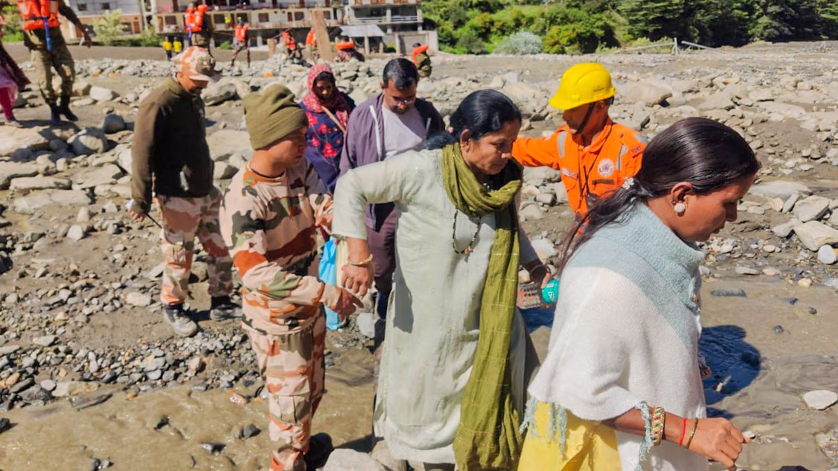
On August 5, 2025, heavy rainfall in Uttarkashi resulted in the sudden flash floods in Dharali and Harsil. The flood, powerful enough to carry soil, rocks, and debris, wreaked havoc. Land subsided beneath homes, roads shattered, and many went missing, isolating the region and complicating relief efforts.
Satellite Reveals the Devastation Secrets
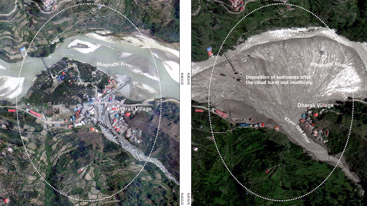
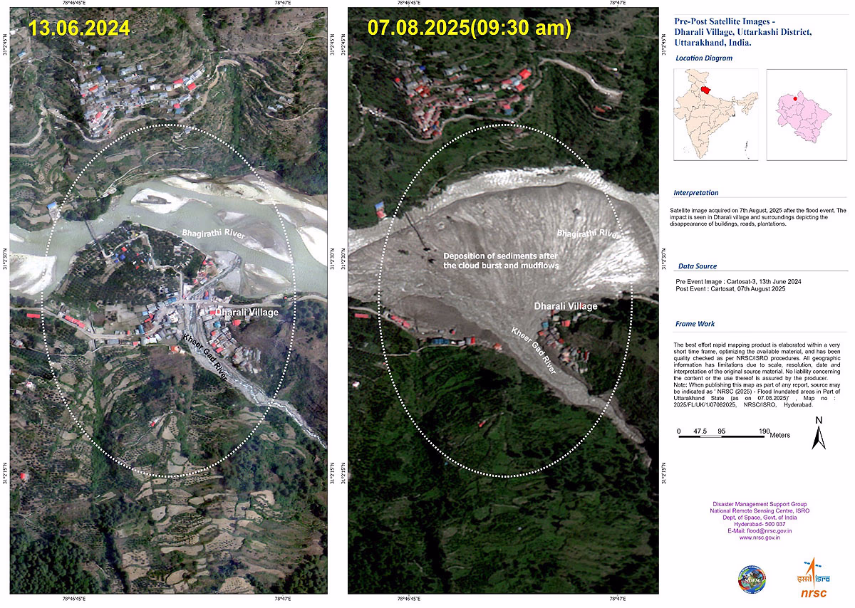
The National Remote Sensing Centre (NRSC) and ISRO utilized high-resolution images from India's Cartosat-2S satellite. They compared post-disaster images from August 7, 2025, with pre-disaster images from June 13, 2024. This analysis unveiled several astounding findings...
Source: aajtak
Traces of the Flash Flood: Satellite images evidenced widened river paths, transformed appearances, and the damage to human lives and infrastructure.
Debris Piled in Dharali: Near the confluence of Khir Ghad and Bhagirathi River in Dharali village, about 20 hectares (750 meters x 450 meters) of soil and debris has accumulated, shaped like a fan.
Destruction of Buildings: Numerous structures were entirely demolished or submerged by flowing soil. Many homes in Dharali village were buried under debris, causing complete ruin.
Assistance in Relief: These images aid relief and rescue operations, helping reach stranded people and reconnect isolated roads.
Increasing Insecurity in the Himalayas
This incident indicates that Himalayan settlements are becoming increasingly insecure. Scientists are investigating the flood's causes, examining possibilities like heavy rain, glacier melting, or structural changes in the terrain. Climate change and human activities might be contributing factors.
Relief and Future Preparation
Armed with satellite data, army and relief teams are working to locate trapped individuals and restore roadways. However, this event underscores the need for caution in fragile regions like the Himalayas. Preventing unplanned constructions and deforestation is crucial to avert such disasters in the future.
Satellite Image Near Uttarkashi: Renewed Rain Threat
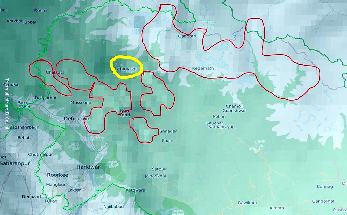
As we write this on Friday, August 8, 2025, recent satellite imagery (combining INSAT-3DR and Bhuvan Map) shows moderate to heavy rainfall activity around Uttarkashi and surrounding areas. This image reveals...
Source: aajtak
Red Zone: Areas like Dehradun, Chakrata, Mussoorie, Kedarnath, Gangotri, and Tehri are likely to experience moderate to heavy rainfall.
Yellow Mark: Representing Uttarkashi, indicating the effect of rainfall.
Weather Improvement and Renewed Threat
On August 7, 2025, weather conditions slightly improved in Uttarkashi and neighboring areas, allowing relief efforts to continue. However, a renewed warning of moderate to heavy rainfall today threatens to disrupt relief and rescue operations.
Impact on Relief Efforts
Rain could increase mud and debris on roads, making it harder for army and relief teams to reach stranded individuals. Helicopter operations may face difficulties due to reduced visibility from clouds and rain. Thus, it is vital for relief teams to plan cautiously based on weather conditions.