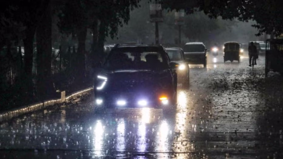
The weather in Delhi turned with a morning twist. Amid falling temperatures, many parts of Delhi experienced light drizzles today. According to the weather department, light to moderate rain is expected in Delhi, NCR, Safidon, Jind, Panipat, Gohana, Ganaur, Hansi, Meham, Sonipat, Tosham, Rohtak, Kharkhoda, Bhiwani, Charkhi Dadri, Matanhel, Jhajjar, Loharu along with Farukhnagar, Kosli, Mahendragarh, Narnaul (Haryana) Baghpat, Khekada (UP) Pilani (Rajasthan) Kurukshetra, Kaithal, Narwana, Karnal, Fatehabad, Rajound, Asandh, Barwala, Adampur, Hisar, Siwani, Sohna, Rewari (Haryana) Gangoh, Hastinapur (UP) Sidhmukh, Sadulpur, Bhiwadi. In the next 2 hours, Jhunjhunu (Rajasthan) may also witness rain. Northern states have been experiencing severe cold and fog strikes.
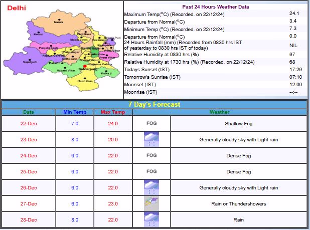
Delhi’s Weather Insight
The weather department has forecasted a potential increase in cold wave conditions in various states. A yellow alert for heavy rain has been issued for coastal Andhra Pradesh on December 20. Dense fog is expected in Delhi throughout the week during mornings and nights.
IMD suggests that chilly winds might further lower temperatures in Delhi in the coming days. The maximum temperature is expected to hover between 23 to 24 degrees Celsius, while the minimum might drop around 5 to 7 degrees Celsius.
Nationwide Weather Update
According to Skymet, over the next 24 hours, light to moderate rainfall accompanied by heavy spells may occur in Andhra Pradesh, North Tamil Nadu, and South Odisha. Rayalaseema, South Interior Karnataka, Lakshadweep, Andaman and Nicobar Islands, South Chhattisgarh, and Odisha might see light to moderate showers. Cold wave conditions could develop in parts of Haryana, Punjab, and Rajasthan. The national capital’s plummeting temperatures have driven people to shelters.
Source: aajtak
Seasonal Activity Nationwide
A depression persists over the southwest Bay of Bengal, complete with an upper atmospheric cyclonic circulation extending up to 5.8 Km above sea level. The system may move towards the North Tamil Nadu and South Andhra Pradesh coast over the next 24 hours, progressing north along the Andhra Pradesh coast. A western disturbance can be marked as a trough in the westerly winds within the lower and mid-troposphere. Further, a cyclonic circulation over Southwest Rajasthan extends up to 1.5 Km above sea level. There's also a cyclonic circulation over Bangladesh.
Temperature Dip Due to Snowfall
Heavy rain and snowfall in the Western Himalayas since the beginning of December have led to significant temperature drops in North India. Such snowfall is crucial for the onset of winter, driven by western disturbances. As these moved forward, the snow-covered peaks dispatched chilly winds across northwest and central India, marking a steep temperature drop. Severe cold wave conditions may be expected in parts of Himachal Pradesh from December 24-26.
Expected Weather Activities in the Next 24 Hours
Light to moderate rainfall is likely in Andaman and Nicobar Islands, Tamil Nadu, Southern Karnataka, Andhra Pradesh, Coastal Odisha, and North Andhra Pradesh's coast. Scattered light rain is possible in North Rajasthan, Haryana, and Delhi. Areas of upper Gilgit-Baltistan, Muzaffarabad, Ladakh, and Jammu & Kashmir might experience light rain and snowfall. Cold wave conditions could develop in parts of Himachal Pradesh, Jammu & Kashmir, Gilgit-Baltistan, and Muzaffarabad, with dense fog envisaged in Himachal Pradesh, Punjab, Haryana, Jharkhand, and Odisha.