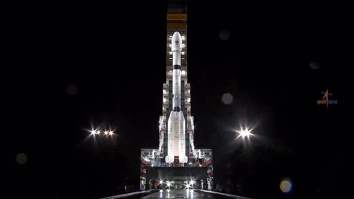
On July 30, 2025, India is set to make history in space again. The NISAR (NASA-ISRO Synthetic Aperture Radar) satellite, a collaborative creation by ISRO and NASA, will be launched from Sriharikota's Satish Dhawan Space Center using the GSLV-F16 rocket. This satellite will meticulously track every terrestrial movement, whether it's clouds, darkness, or forests. For farmers, scientists, and disaster relief teams, this satellite is a true game-changer.
What is NISAR?
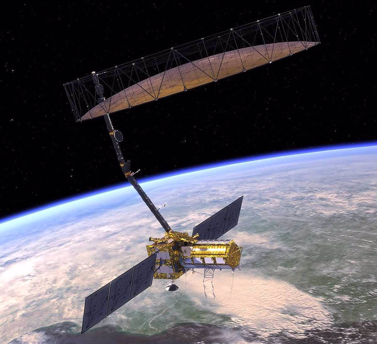
NISAR is a satellite dedicated to observing Earth, born from the partnership between NASA (USA) and ISRO (India). Officially named NASA-ISRO Synthetic Aperture Radar, it's the world's first satellite to utilize dual-frequency radar (L-band and S-band). This means it scans the Earth's surface with two different types of radio waves, providing highly accurate imagery.
Weight: 2,392 kg
Launch: July 30, 2025, at 5:30 PM IST, aboard the GSLV-F16 rocket.
Mission Duration: At least 3 years, mapping the world every 12 days.
Altitude: Positioned in a sun-synchronous orbit at 743 km, ensuring continuous operation in sunlight.
Cost: Approximately $1.5 billion (around 1.25 lakh crore Rupees), making it the costliest Earth observation satellite worldwide.
NISAR's 12-meter mesh antenna, compared to a large umbrella, and its innovative SweepSAR technology enable it to scan wide swaths up to 242 km with 5-10 meter precision, detecting movements as small as 1 centimeter.
How does NISAR work?
NISAR employs Synthetic Aperture Radar (SAR) technology to capture images via radio waves, a departure from traditional cameras, because...
It transcends clouds, fog, and the dark: Capable of seeing through clouds and in darkness.
Operates 24/7: Collects data around the clock, in all weather conditions.
Dual Radar
L-band (NASA):
Penetrates dense forests and beneath the soil, ideal for monitoring earthquakes, volcanoes, and ice.
S-band (ISRO):
Offers insights into soil moisture and crop conditions.
SweepSAR:
Making its debut, this technology scans extensive areas in high resolution.
Example:
Imagine a potential earthquake in the Himalayas—NISAR can detect ground movement as slight as 1 centimeter, enabling early alerts.
What will NISAR monitor?
NISAR will keep a vigilant watch over Earth's phenomena, focusing on...
Monitoring Natural Disasters
Earthquakes: Tracks tectonic movements at the centimeter level.
Volcanoes: Detects lava movements in advance.
Landslides and Tsunamis: Provides early warnings in the Himalayas and coastal regions.
Climate Change
Glaciers and Ice: Measures melting rates in the Himalayas and Antarctica, helping predict sea level rise.
Forests: Observes deforestation and vegetation conditions.
Weather: Gathers data on soil moisture and water sources.
Agriculture and Water Management
Crops:
Supplies information on crop conditions, soil moisture, and farming patterns.
Water:
Monitors groundwater and rivers, aiding drought prediction.
Disaster Relief
Offers real-time data during floods, storms, or forest fires to assist in relief operations. Example: It could have expedited rescue operations during the 2023 Himachal floods.
Coastal Monitoring:
Observes coastal erosion and sea ice conditions.
Key Feature:
NISAR's data will be freely accessible. This benefits scientists, governments, and the public alike, as it sends 85 terabytes of data daily, equivalent to millions of phone photos.
India's Contribution
ISRO has played an equal role in NISAR. India's contributions include...
S-band radar: Developed by the Space Applications Centre (SAC) in Ahmedabad.
Satellite body (bus): Built by ISRO, forming the core structure of the satellite.
Launch vehicle: GSLV-F16 rocket, India's most powerful.
Launch site: Sriharikota's Satish Dhawan Space Center.
Testing: Conducted at ISRO's Satellite Integration and Testing Facility in Bengaluru.
NASA contributed the L-band radar, 12-meter mesh antenna, GPS, and data systems. Together, they collaborated to create the satellite.
Source: aajtak
The Journey of NISAR
NISAR's journey began in 2014 when NASA and ISRO signed an agreement. However, the path wasn't easy...
Delays: Originally planned for a 2022 launch, a heating issue arose in the radar antenna, necessitating repairs in California.
Transport: In October 2024, NASA's C-130 cargo plane delivered it to India, via Hawaii, Guam, and the Philippines, arriving at Bengaluru's HAL Airport.
Preparation: Testing concluded in Bengaluru by January 2025. Now, the satellite has been integrated with the GSLV-F16 rocket.
The GSLV-F16 has been moved from the Vehicle Assembly Building to the Umbilical Tower, marking the final steps before launch.
Why is this crucial for India?
Disaster Management
From Himalayas earthquakes to landslides in Himachal or cyclones in Odisha — NISAR will provide early warnings.
Agriculture and Water
India's agricultural relies heavily on the monsoon. NISAR will inform farmers of soil moisture, enabling better planning. In groundwater-deficient areas (like Punjab, Haryana), water management becomes more efficient.
Climate Change
Himalayan Glaciers:
Tracks the melting sources of rivers like the Ganges and Yamuna. Coastal cities (Chennai, Mumbai) will benefit from sea-level rise alerts.
Scientific Advancement
India's S-band radar technology gains global recognition. This mission is significant for competitive exams, highlighting India's space capabilities.
International Reputation:
Partnering with NASA enhances India's global space technology standing.
Challenges
Cost: A project costing 1.25 lakh crore rupees represents a significant investment.
Technical Complexity: Managing dual radar and SweepSAR operations can be challenging.
Data Management: Processing 85 terabytes of data daily is no easy task.
Delays: Learning from prior delays (2022, 2024) is crucial.