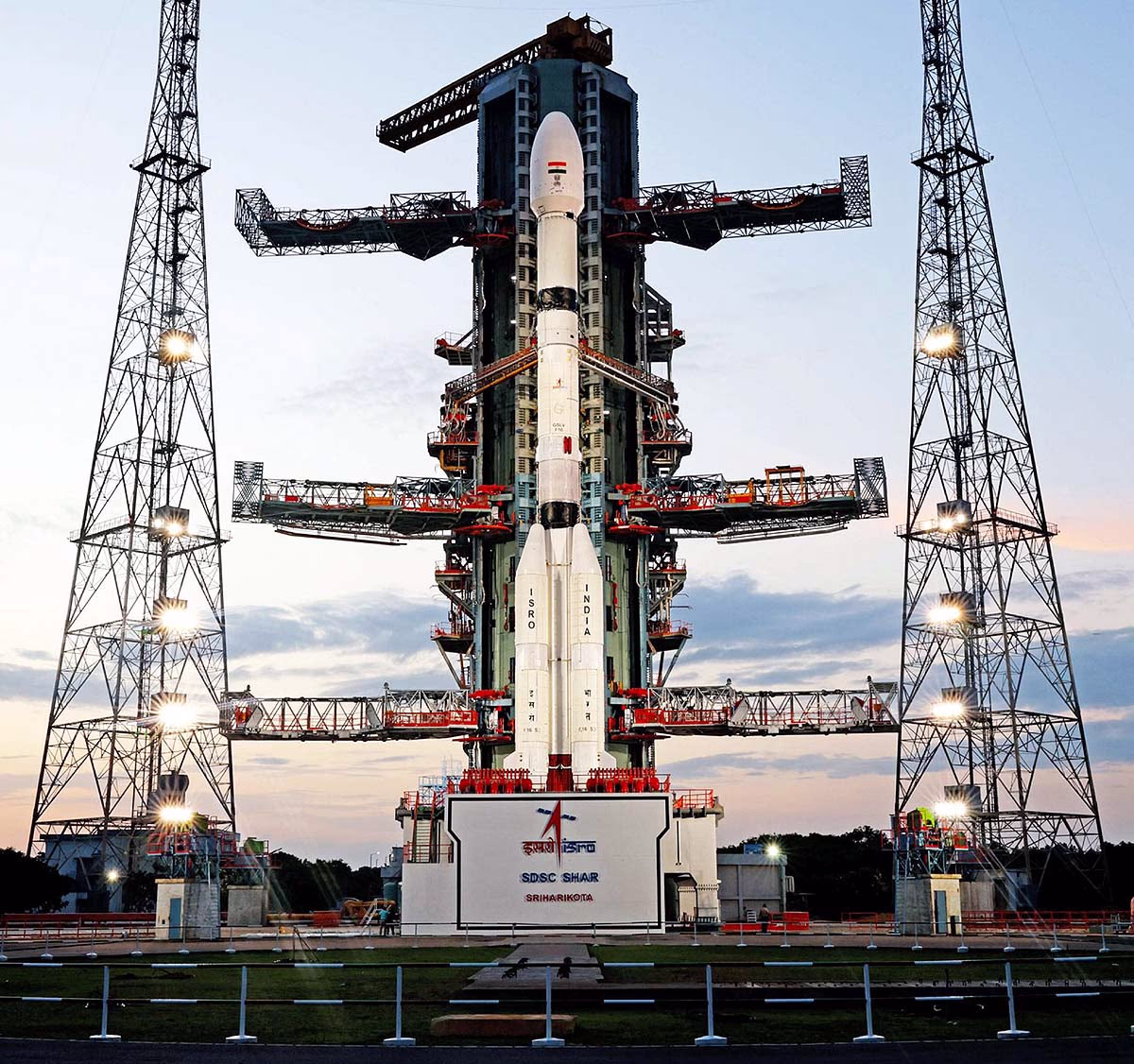
On July 30, 2025, a historic mission backed by India and the USA is set to unfold. The NISAR (NASA-ISRO Synthetic Aperture Radar) satellite, often referred to as Earth's MRI scanner, will be launched today at 5:40 PM from the Satish Dhawan Space Centre in Sriharikota.
This satellite will forewarn about natural disasters such as earthquakes, tsunamis, volcanoes, and landslides. Jointly developed by India's ISRO and America's NASA, it represents the world's first satellite equipped with dual radar frequencies (L-band and S-band) to scan Earth's surface.
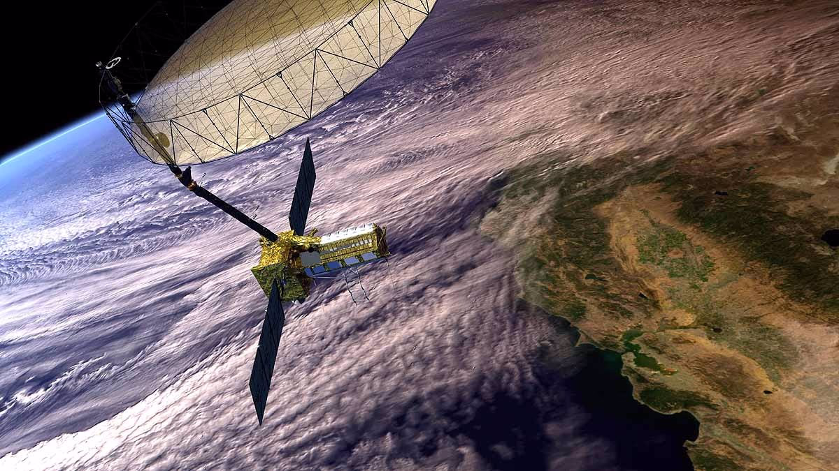
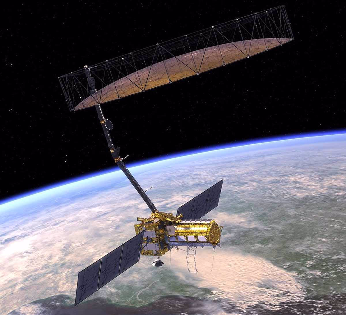
NISAR, a low earth orbit (LEO) satellite, built collaboratively by NASA and ISRO, stands for NASA-ISRO Synthetic Aperture Radar. Its purpose is to scan Earth's surface, ice, and forests. Dubbed as Earth's 'MRI scanner,' it captures extremely detailed images of Earth, detecting changes down to the centimeter level, akin to a doctor scrutinizing internal details through an MRI scan.
Every 12 days, this satellite will completely scan our planet and aid in providing alerts for natural calamities like earthquakes, tsunamis, volcanoes, and landslides. This mission, with an expenditure of 130 billion rupees (1.5 billion dollars), sees ISRO contributing 7.88 billion rupees. The data will be freely accessible to scientists, governments, and the general public worldwide.
Source: aajtak
Launch and Technical Information
Launch Date & Time: July 30, 2025, 5:40 PM IST, from Satish Dhawan Space Centre, Sriharikota.
Launch Vehicle: ISRO's GSLV-F16 rocket. Uniquely, this marks the first time GSLV will propel a satellite into a sun-synchronous orbit, typically executed by PSLV.
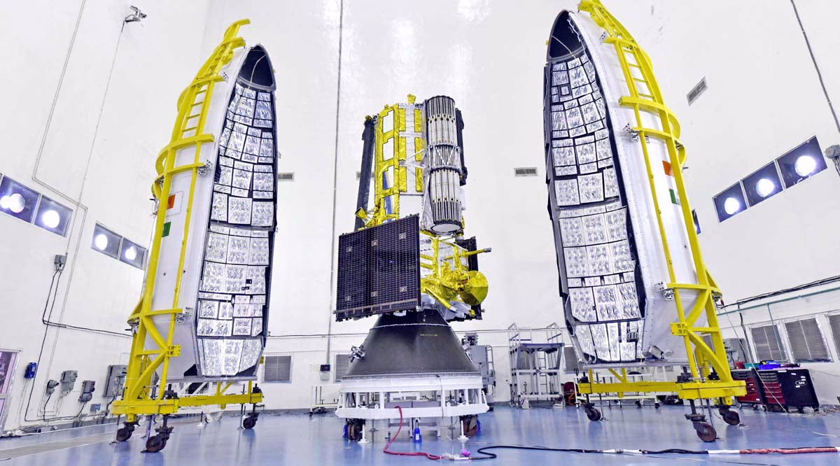
Weight: 2,392-2,800 kg (akin to an SUV).
Orbit: 747 km altitude, sun-synchronous orbit, 98.4° inclination.
Mission Duration: 3 years, potentially extending to 5 years based on fuel and stability.
Data Output: Producing 80 terabytes of data daily, nearing the capacity of 150 hard drives (512 GB each).
Antenna: A sprawling 12-meter wire mesh antenna, engineered by NASA's Jet Propulsion Laboratory (JPL).
Power: Generates 6,500 watts of power, sourced from large solar panels.
Dual Radar System (L-band & S-band):
NISAR stands as the inaugural satellite worldwide utilizing distinct radar frequencies—NASA's L-band (with a wavelength of 24 cm) and ISRO's S-band (with a wavelength of 9 cm).
L-band:
This penetrates dense forests, snow, and soil layers, capturing activities below. For instance, it can detect movements in the ground before an earthquake, or activities below volcanoes.
S-band:
Focusing on finer details like crop structures, ice layers, and soil moisture, this radar provides accurate images with 5-10 meters precision, spanning 242 km wide areas.
All-weather Functionality:
Unlike satellites with optical cameras that fail under clouds or at night, NISAR's radar captures images nonstop through clouds, smoke, and forests in any weather and around the clock.
Full Earth Scan in 12 days:
Every 12 days, NISAR will scan Earth's land and icy surfaces entirely, yielding data roughly every 6 days. Positioned in a sun-synchronous orbit (747 km up, with a 98.4° tilt), it receives consistent sunlight.
Source: aajtak
Detecting changes down to the centimeter in Earth's surface is possible with this satellite. For example, it measures minor tremors before an earthquake, volcanic activities, or assesses dam stability.
12-meter Large Antenna:
NISAR features a colossal 12-meter wire mesh antenna, NASA's largest to date, which unfolds post-launch to facilitate radar signal transmission and reception.
SweepSAR Technology:
Leveraging SweepSAR technology, NISAR can scan extensive areas at high resolution concurrently, creating images by sending radar signals and capturing their return.
Free Data Policy:
Data from NISAR will be freely available within 1-2 days, and even quicker in emergencies. Governments, scientists, and disaster management teams globally can exploit this data.
How does NISAR Provide Early Alerts for Natural Disasters?
NISAR's paramount advantage lies in its ability to forewarn about natural disasters. Let's explore how it functions:
By measuring minute movements on the ground, NISAR captures seismic activities along fault lines preceding an earthquake. It can identify regions with elevated earthquake risk zones. Observing ground swelling or movements around volcanoes allows NISAR to predict potential eruptions.
Precise earthquake data is crucial for tsunami alerts. NISAR provides data on seismic activities before and after earthquakes, informing tsunami likelihood assessments, while monitoring flood conditions in coastal areas.
In hilly terrains, NISAR detects soil and rock movements, alerting potential landslide zones. This is vital for countries like India, where Himalayan regions often experience landslides.
NISAR measures soil moisture and water levels in rivers and lakes, tracking water spread during floods to support relief operations. It also monitors storm impacts.
Infrastructure Monitoring:
NISAR evaluates structural stability—dams, bridges, and other infrastructure—by measuring ground movements, detecting any early signs of structural failure.
Climate Change Monitoring:
NISAR tracks ice sheet melting, glaciers, and sea ice, aiding understanding of rising sea levels and climate change effects.
Agriculture and Forests:
Monitoring crop conditions, forest biomass, and deforestation, it supports crop management and food security in agriculture-centric countries like India.
Source: aajtak
NISAR aids water resource management by measuring soil moisture and groundwater levels, beneficial for flood-prone regions such as Assam and Kerala.
NISAR helps protect marine environments by tracking coastal erosion, sea ice, and oil spills.
Global Collaboration:
Symbolizing a decade-long collaborative scientific effort between India and the USA, NISAR will offer free data to countries worldwide, bolstering disaster management and climate strategies, especially for developing nations.
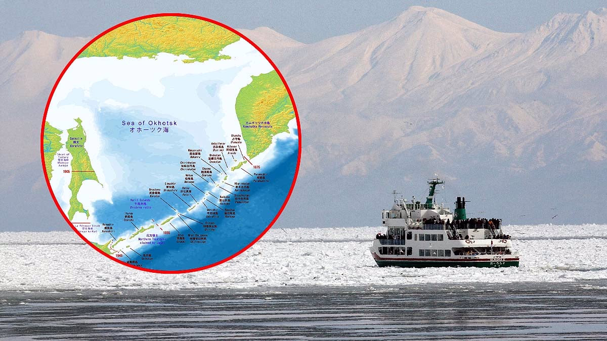
NISAR and Kamchatka Earthquake Tsunami
On July 30, 2025, the magnitude 8.8 earthquake in Kamchatka, Russia, posed tsunami threats in the Pacific Ocean and the Sea of Okhotsk. Future satellite technologies like NISAR can pre-emptively warn about such disasters, detecting seismic activities along fault lines before earthquakes occur and monitoring coastal flooding post-tsunami. NISAR's data will expedite and enhance relief efforts.