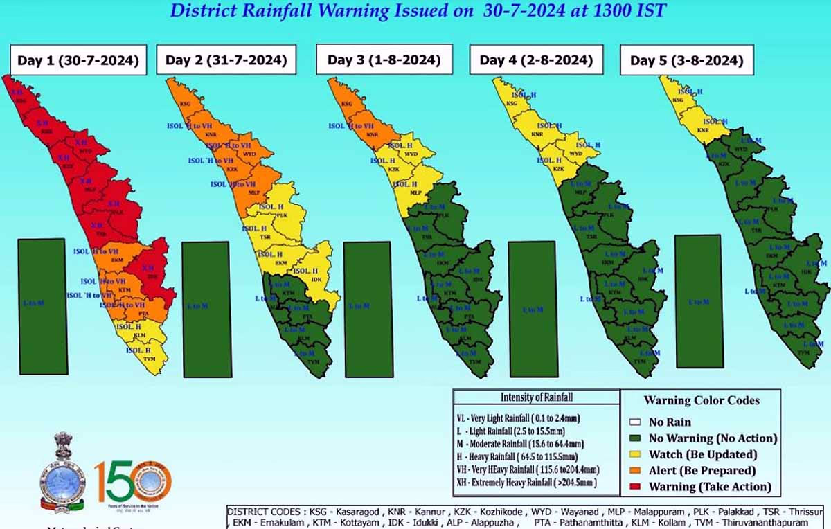
The Arabian Sea's warmth and a mass of clouds above it have led to devastating conditions in Kerala. The coming week still poses significant risks. According to the weather department, powerful winds are expected in Kerala's lower regions over the next 2-3 days. From July 30th to August 2nd, several areas, including Wayanad, may experience heavy rainfall and thunderstorms.
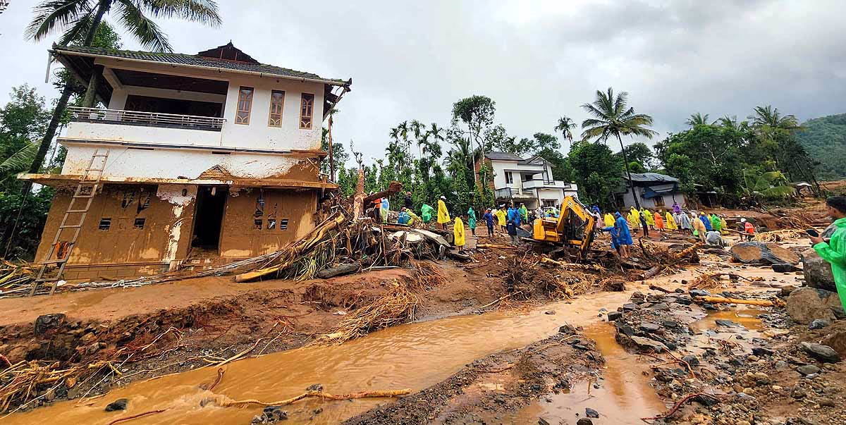
The weather department specifically stated that from July 30th to 31st, intense rainfall is expected. The first 24 hours may see 7 to 11 centimeters of rain, and the next day could bring 12 to 20 centimeters. Wayanad, Idukki, Thrissur, Palakkad, Kozhikode, Kannur, and Kasaragod will be affected. Rescue operations continue in Wayanad amidst the rain.
Read More:
Source: aajtak
Winds over the sea are moving at speeds of 35 to 45 kilometers per hour. Fishermen are advised not to venture into the sea. There is a high possibility of flash floods, damage to houses, uprooting of trees, and disruption in electricity supply.
Why so much rain?
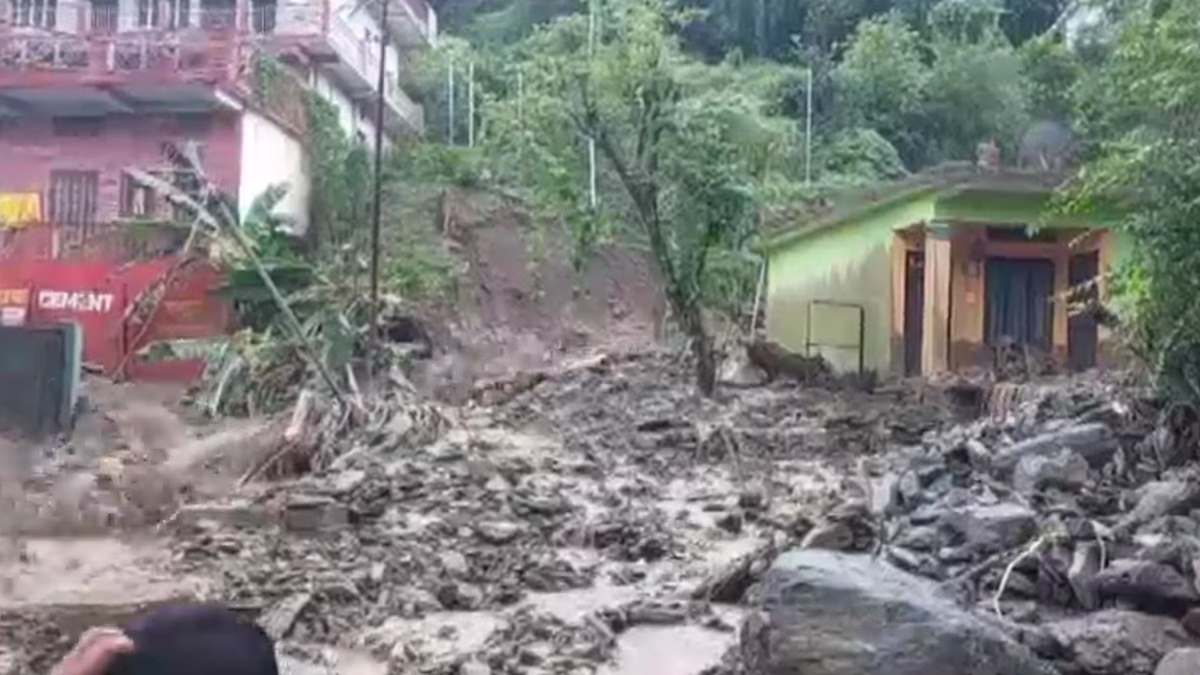
Satellite images from the weather department reveal a congregation of clouds near Kerala. There's a chance that the high mountains of the Western Ghats east of Kerala are obstructing the movement of these clouds, reminiscent of the 2013 Kedarnath tragedy where clouds got trapped in the mountains. This is why such severe devastation has occurred in Wayanad.
Read More: Non Stop 100: 24-hour Red Alert issued in Wayanad, Death Toll Rising
Source: aajtak
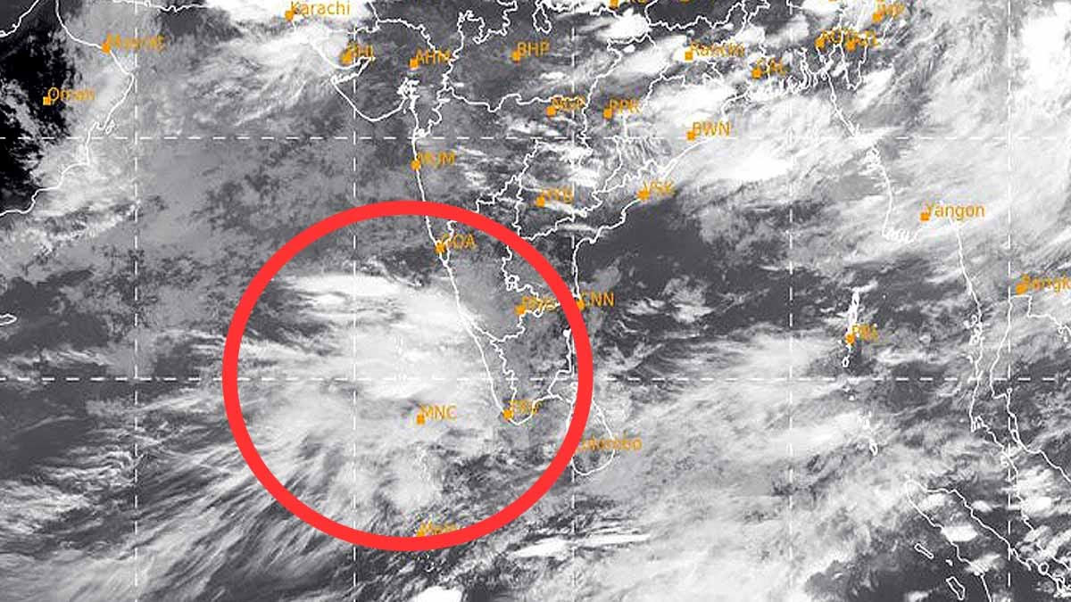
The Arabian Sea is warming rapidly. A. Abhilash, Director of the Advanced Center for Atmospheric Radar Research at Cochin University, explained that areas like Kasaragod, Kannur, Wayanad, Kozhikode, and Malappuram are experiencing heavy rain. A trough in the sea is affecting the entire Konkan region for the past two days, creating a scenario similar to 2019. There's a mesoscale cloud system in place at this time.
The reason behind the cloud mass
Scientists have observed the development of a very deep cloud system near Kerala in the southern part of the Arabian Sea. This system typically remains over the sea but sometimes moves towards land, as happened in 2019. The continuous warming of the Arabian Sea due to climate change is a significant factor.
Read More:
Source: aajtak
This impacts Kerala's atmospheric conditions, causing a thermodynamic imbalance that results in dense cloud formations. Previously, such weather was common in the northern Konkan region near northern Mangalore, but it is now moving southwards due to changing climate patterns.
51% of Wayanad is on Slopes
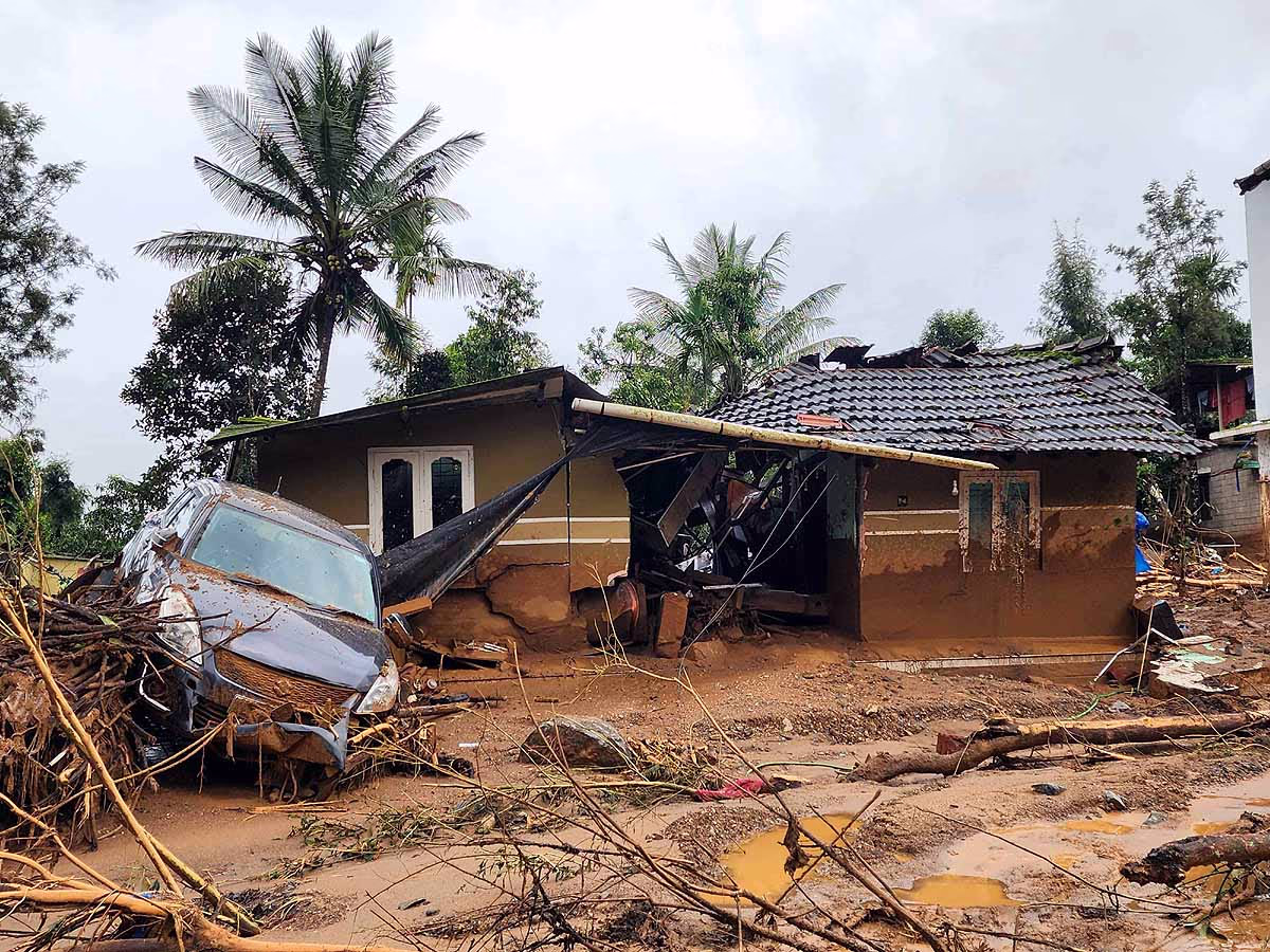
According to the Geological Survey of India, 43% of Kerala's total area is prone to landslides. Idukki's 74% and Wayanad's 51% of the land are on mountainous slopes, making landslides a constant threat. The Western Ghats, including Wayanad, Kozhikode, Malappuram, Idukki, Kottayam, and Pathanamthitta, are the most affected. In 2019, these eight districts experienced 80 landslides in just three days, causing 120 fatalities. In 2018, ten districts witnessed 341 major landslides.
Read More:
Is Wayanad's Terrain Uneven?
A plateau area over 2695 meters, about 8841 feet high. The Western Ghats make up 40% of Kerala's area, a region characterized by extreme humidity and forested terrain, where even short bursts of rain can trigger landslides. Situated in this zone is Wayanad, which spans 2130 square kilometers and is geographically divided into four parts: the Peninsular Genesis Complex, Migmatite Complex, Charnockite Group, and Wayanad Group. The Wayanad Group's stones are in the northern area, with Charnockite in the south and southeastern regions. This categorization is a way to chemically and geologically describe the soil and rocks. The district sits at an altitude of 2084 meters.
Source: aajtak
Most of the water supply in the district comes from the Kabani River and its branches. Flooding in the plains is expected due to the surrounding mountains. The district's eastern area is between 1000 and 1400 meters high, with most of the land composed of clay-like soil, making it weak and prone to landslides.
Why so many landslides?
Deforestation...
Kerala has been known for its tea plantations for over a century. However, reduced biodiversity in the forests has led to significant deforestation. Climate change has altered rainfall patterns, increasing the frequency of landslides in slope areas.
Geographical Location...
The district is located on the steep slopes of the Western Ghats, with valleys and mountains contributing to the higher risk of landslides.
Source: aajtak
Heavy Rainfall...
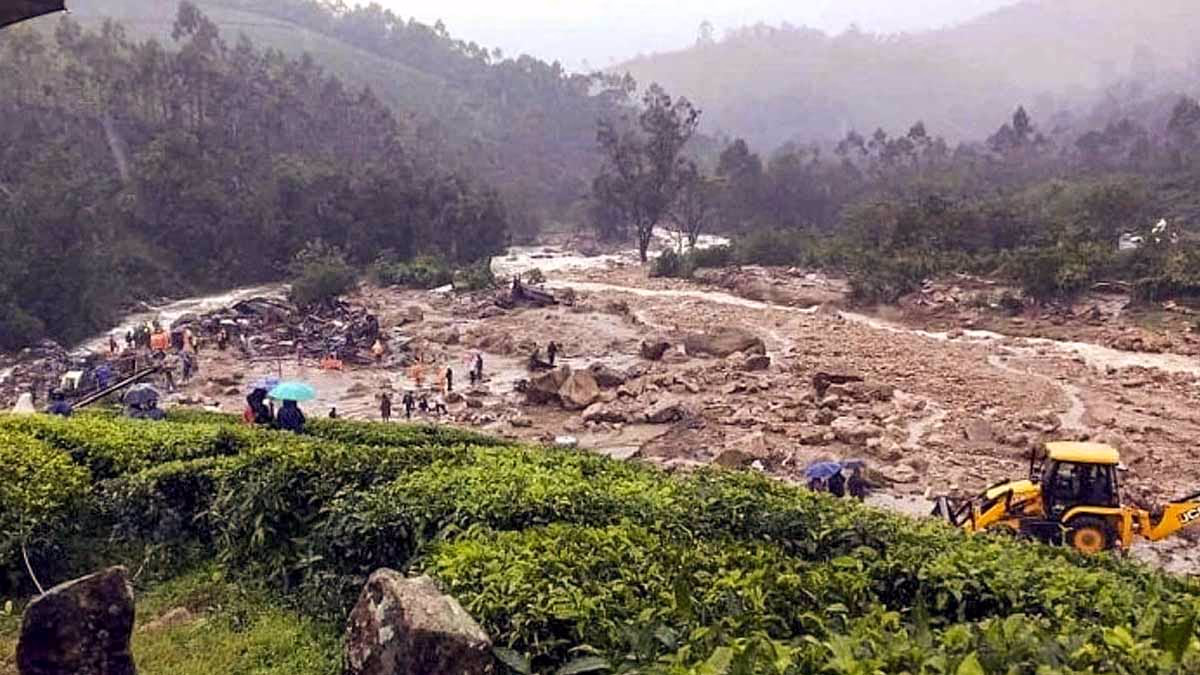
During the monsoon season, Wayanad often endures over 2000 millimeters of rain, saturating the soil and causing it to erode and resulting in landslides.
Soil Quality...
Most of Wayanad's soil is laterite, which is extremely weak and prone to erosion. When saturated with rain, the soil becomes heavier but loses strength, making it more susceptible to landslides.
Poor Land Usage Brings Big Trouble
A decade ago, the National Center for Earth Studies mapped a hazard zone. Areas once considered safe are now at risk. In 2018-19, 41% of landslides in Wayanad's Vyathiri occurred around houses built on slopes, 29% on roadsides, 17% on commercial lands, 10% in areas with trees, and only 3% in forests. Changes in land use have significantly contributed to this natural disaster.