
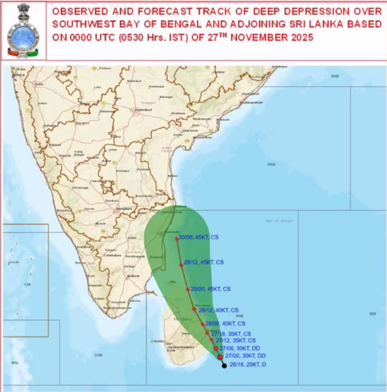
As Cyclone Senyar weakens, a new storm brews in the Bay of Bengal. The India Meteorological Department (IMD) advises vigilance for coastal districts of Tamil Nadu and Andhra Pradesh. They reported that a depression near the southwest Bay of Bengal and the Sri Lanka coast has intensified into a deep depression. The IMD predicts a high chance of it evolving into a cyclonic storm within the next 12 hours.
Cyclone Ditwah
Once formed, this cyclone will be known as 'Cyclone Ditwah'. The department anticipates heavy rainfall, winds between 80–90 km/h, and high sea waves in the coastal regions of Tamil Nadu, Puducherry, and Southern Andhra Pradesh by the end of the week.
The IMD detailed that the weather system will progress north-northwestward from the southwest Bay of Bengal near Sri Lanka, intensifying over time. Most models indicate that this system will remain in the same region for at least the next 24 hours, gaining strength.
Officials stated that the storm will move nearly parallel to the Sri Lankan coast, entering the southwest Bay of Bengal near the Tamil Nadu–Puducherry coastline by November 29. Weather experts noted that the depression will hover over southeastern Sri Lanka and adjacent seas for the next two days before advancing toward the Indian coast.
Source: aajtak
Advisory to Stay Away from the Sea
Cyclone Senyar, active in the Strait of Malacca and northeastern parts of Indonesia, is now weakening. The IMD reported that Senyar will gradually turn into a deep depression, moving eastward and dissipating by Thursday evening. Despite its weakening, heavy rains are possible in some areas of the Andaman and Nicobar Islands in the coming days.
Coastal state officials have advised fishermen to avoid the sea and urged locals to stay informed with continually updated information, as another storm is brewing in the Bay of Bengal.