The joint Earth-observation satellite mission NISAR by NASA and ISRO has marked a monumental achievement. Its colossal radar antenna reflector has successfully unfurled in space, confirmed by @NASAJPL. This milestone readies it for precise studies of Earth's shifting surfaces. Let's explore what this mission entails, how it operates, and its benefits.
What is NISAR?
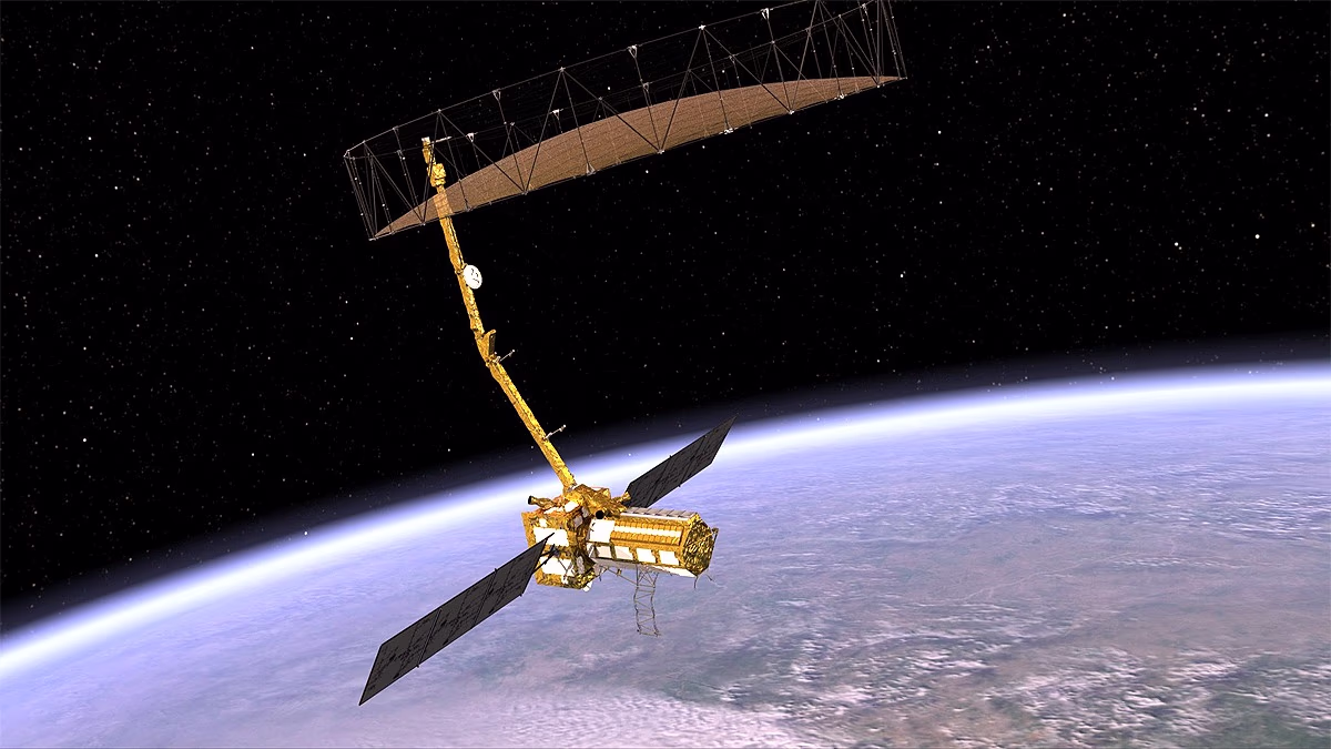
NISAR (NASA-ISRO Synthetic Aperture Radar) is a satellite designed to measure changes on Earth's surface. Launched on July 30, 2025, from the Satish Dhawan Space Center in Sriharikota, India, it will scan most of Earth's regions twice every 12 days. Its mission is to provide data on natural disasters, climate change, and food-water security issues.
Successful Deployment of the Antenna Reflector
The centerpiece of NISAR is its 12-meter diameter drum-like radar antenna reflector, kept folded post-launch. From August 9 to 13, it was gradually extended on a 9-meter boom. On August 15, small explosive bolts were fired, initiating the 'bloom' process. This process, akin to opening an umbrella, saw the antenna lock into its final position with motor-cable assistance.
Nasa's Jet Propulsion Laboratory (JPL) Project Manager Phil Barella stated that observing this largest antenna reflector unfold successfully in space is the culmination of years of design, testing, and collaboration. The 64-kilogram antenna is built from 123 composite struts with a gold-coated mesh.
How Does It Work?
Utilizing this antenna, NISAR can measure surface changes on Earth to centimeter precision, irrespective of cloudy skies, darkness, or dense forests. It employs two radar systems:
L-band radar: Operates through clouds and forests.
S-band radar: Measures moisture in thin vegetation and ice.
Equipped with 'Interferometric SAR Imaging' technology, it compares radar images over time to reveal minute land changes. This technology creates 3D movie-like images, surpassing conventional radar capabilities.
NISAR's Purpose and Benefits
NISAR will monitor multiple Earth aspects, including:
Glaciers and Ice: Provides insights into glacier movements and melting.
Earthquakes and Volcanoes: Measures changes in fault zones and volcanoes.
Forests and Wetlands: Displays changes in vegetation, wetlands, and ecology.
Natural Disasters: Warns of floods, landslides, and volcanic eruptions.
Food and Water Security: Monitors crops and water sources.
Karen St. Germain, Director of NASA's Earth Science Division, states that this mission will help us understand Earth's dynamic systems. The data empowers communities and decision-making, leading to improved infrastructure and enhanced disaster management and food-water security.
NISAR's Legacy and Future
NISAR extends JPL's radar technology heritage, beginning with the 1978 Seasat and 1990 Magellan missions (which mapped Venus). With the antenna deployed, final system checks are underway. JPL indicates that the mission will commence data output later this year (late fall).