The tragic incident involving three youths whose car plummeted from a bridge in Bareilly while they were on their way to a wedding has sparked widespread discussion. This unfortunate event took place on November 23 and has reignited debates about over-reliance on navigation apps, reminiscent of past occurrences with similar consequences.
Google Maps stands as a leader in navigation technology, utilized by millions daily to plan journeys with road, curve, and lane details. Yet, the question arises: How could Google Maps make such a grievous error by guiding users onto a closed road?
What Technology Does it Use?
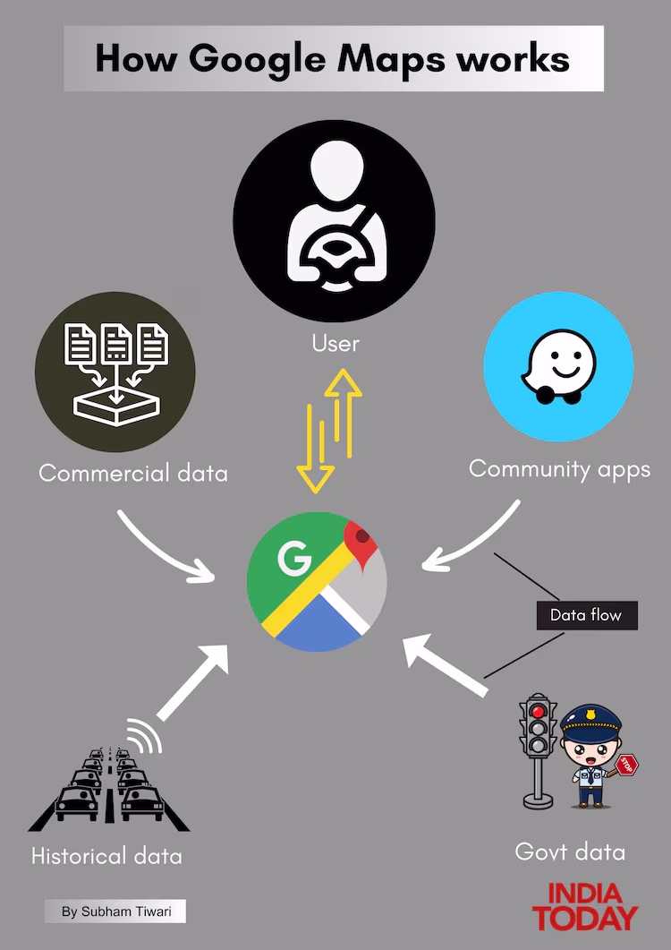
The exact technology behind Google Maps remains a closely guarded business secret and is not open-source. Reports suggest it employs Dijkstra's algorithm for calculating the shortest path from point A to point B, renowned for its efficiency in solving shortest route problems.
Google Maps recommends optimal routes primarily based on data from two sources: other users and local authorities. Its 'Road Update' feature allows users to report missing or closed roads, enhancing real-time accuracy.
Partnership for Local Geospatial Data!
Google Maps partners with private organizations and government entities at various levels for reliable geospatial data, aiming to refine its app. However, specifics on which state or local bodies in India officially share data with Google remain unclear.
In the Bareilly case, a senior traffic police official mentioned to India Today their uncertainty about any traffic data being shared with Google. Ethical considerations pose potential challenges for public agencies voluntarily sharing data with a commercial entity like Google.
Source: aajtak
Google India, when probed about data partnerships, only commented on the Bareilly accident, expressing condolences and stating their cooperation with authorities in the investigation.
Could This Tragedy Have Been Prevented?
Many argue Google Maps could have averted the Bareilly tragedy, pointing out the app’s vast user data collection. The bridge had been out for over a year. So, how could Maps suggest a closed road for over a year?
National Road Safety Mission head, Amit Yadav, believes Google should identify such anomalies potentially preventing mishaps.
Remote sensing expert Raj Bhagat points out that this issue isn't unique to Google Maps. Other navigation apps like MapMyIndia's Mappls also guide users on similar paths irrespective of the app.
The Bareilly Incident Explained
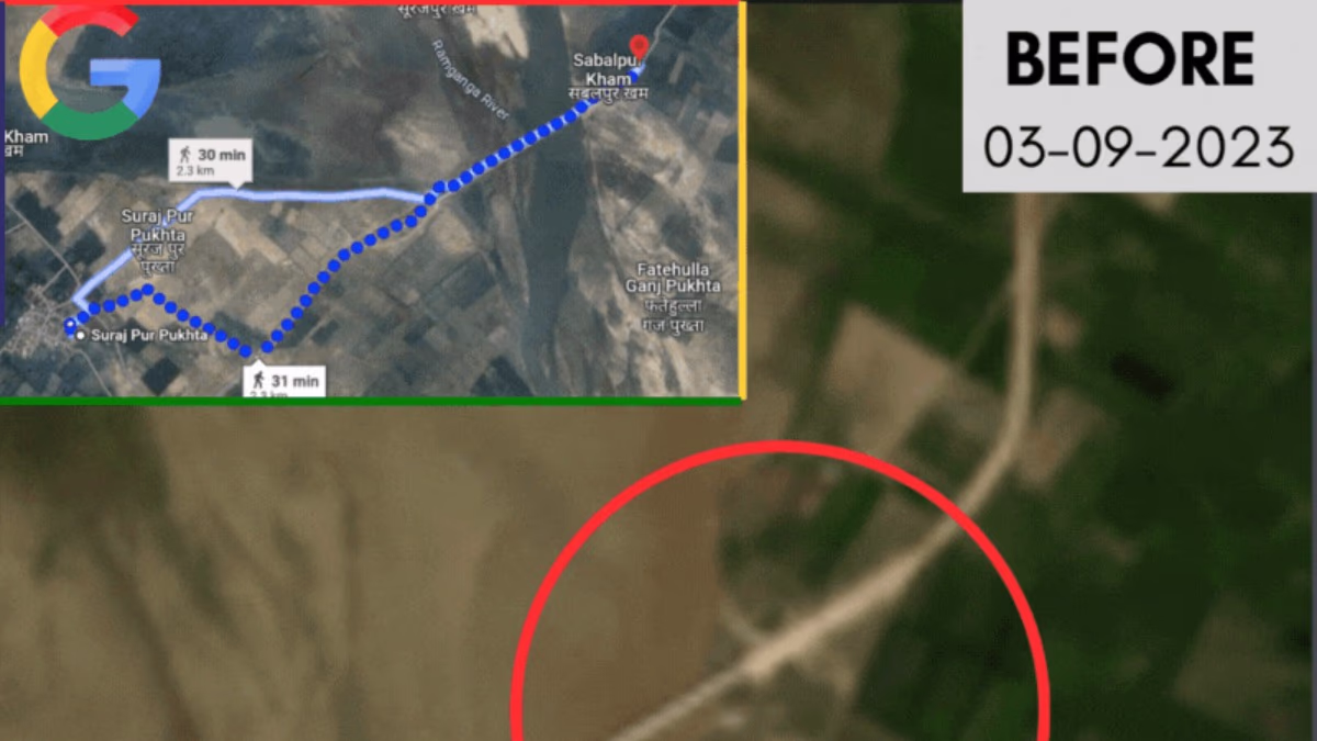
Nitin Kumar, along with relatives Ajit Kumar and Amit, was traveling to Bareilly from Gurgaon on the night of November 23. Unaware of the incomplete bridge near Khalpur village, they met their tragic fate. Satellite images reviewed by India Today show the bridge partially collapsed in September 2023 due to flooding.
Local police found the Google Maps app open on the driver's smartphone, indicating its usage for navigation. By Monday, November 25, India Today found Google Maps still directing pedestrian routes over the afflicted bridge, while routes for vehicles were unavailable, necessitating river crossing by boat.